About Surveyor Topographer

We are a team of professional topographical surveyors dedicated to providing accurate, reliable land surveys and topographic survey services across the United Kingdom. With decades of combined experience, our survey team uses the latest surveying technology and highly specialised survey equipment to deliver exceptional results.

Our Story

Surveyor Topographer was founded with a clear mission: to provide property buyers, sellers, architects, and developers with the most accurate and comprehensive topographic surveys available. As experienced land surveyors, we understand the importance of topographic surveys in preventing costly mistakes and ensuring construction projects proceed smoothly.

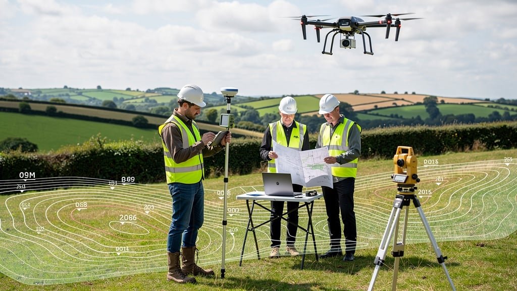
Over the years, we've conducted thousands of topographical land surveys across the UK, from small residential plots to large-scale civil engineering projects. Each survey is approached with the same level of professionalism and attention to detail, whether it's a measured survey for a home extension or a comprehensive land survey for a major development project.

Our commitment to using modern topographical surveys technology, including accurate GPS equipment, drone survey capabilities, and advanced CAD software, means our clients receive survey results that meet the exacting standards required by architects, local authorities, and planning permission applications.

15+
Years Experience
5,000+
Surveys Completed
98%
Client Satisfaction
Professional topographic survey team using GPS equipment and surveying technology

Why Property Buyers and Developers Trust Surveyor Topographer

When you need a topographic survey, you want a survey company that delivers accurate land data, understands your survey needs, and provides professional service throughout the survey process.

Professional Accreditation

All our topographical surveyors hold professional accreditation, giving you confidence in the quality and accuracy of every land survey we conduct.

Latest Surveying Technology

We invest in modern surveying technology including drone survey equipment, laser scanners, and accurate GPS equipment to capture every detail of natural and man-made features.

Fast Turnaround

We understand project deadlines. Our survey team works efficiently to deliver CAD drawings and survey results quickly without compromising on the level of detail or accuracy.

Fully Insured

Comprehensive professional indemnity and public liability insurance protects both our clients and our survey team during every topographic land survey we undertake.

Competitive Pricing

Our topographic survey costs are transparent and competitive. We provide detailed quotes upfront so you understand exactly what your survey will cost.

Exceptional Support

From initial consultation to post-survey support, our team is always available to answer questions about your survey data, CAD drawings, or any aspect of the survey process.

Meet Our Expert Survey Team

Our professional topographical surveyors bring decades of experience in conducting measured surveys, land surveys, and topographic surveys for clients across the UK.

Senior Land Surveyor conducting topographic survey

Richard Thompson

Senior Land Surveyor & Director

With over 20 years of experience in topographic surveys and land surveying, Richard leads our survey team with a focus on delivering accurate survey data for complex engineering and construction projects. His expertise in GPS equipment and modern surveying technology ensures every topographical survey meets the highest standards.

Richard has conducted surveys for major infrastructure developments, residential estates, and commercial properties across the UK. His deep understanding of planning permission requirements and flood risk assessment makes him an invaluable resource for architects and developers.

Professional topographical surveyor with survey equipment

Emily Richardson

Senior Topographical Surveyor

Emily specialises in detailed topographical land surveys and measured surveys for property development. Her meticulous approach to capturing contour lines, spot levels, and natural topographic features ensures architects receive the comprehensive survey results they need for successful project planning.

A specialist in drone survey technology and CAD drawings, Emily has helped hundreds of property buyers understand their land through accurate topographic data. She regularly works with local authorities and architects on land development projects requiring precise survey control.

Experienced land surveyor reviewing topographic survey plans

David Marshall

Principal Surveyor

David brings 25 years of experience in conducting topographic surveys for civil engineering projects and large-scale land development. His expertise in using highly specialised survey equipment, including total stations and accurate GPS equipment, ensures precision in every survey.

David has managed survey projects for major construction companies throughout the UK, providing survey services that help prevent costly mistakes and unforeseen issues. His knowledge of Ordnance Survey standards and survey control methodologies is second to none in the industry.

Our Professional Accreditations

Surveyor Topographer is proud to maintain professional memberships and accreditations with leading industry bodies, demonstrating our commitment to excellence in topographic survey services.

CIOB

Chartered Institute of Building accreditation ensures our land surveyors meet rigorous professional standards in construction and surveying.

RICS

Royal Institution of Chartered Surveyors certification guarantees our topographical surveyors maintain the highest professional and ethical standards.

RPSA

Residential Property Surveyors Association membership demonstrates our expertise in property surveys for both buyers and sellers.

Ready to Work With Our Expert Team?

Whether you need a topographic survey for planning permission, a measured survey for a construction project, or a land survey for property purchase, our professional team is ready to help.