Surveyor Topographer: Expert Land & Topographic Survey Services

Professional topographic surveys, measured land surveys, and precise CAD drawings for property buyers, sellers, architects, and developers. Our experienced land surveyors provide accurate survey data to avoid costly mistakes and ensure your construction project starts on solid ground.

CIOB Accredited
RICS Certified
RPSA Members

Request a Free Survey Quote

Complete the form below and our expert surveyors will contact you within 24 hours to discuss your topographic survey needs.

Why Choose Surveyor Topographer?

Getting a topographical survey from our professional team ensures accurate data, prevents unforeseen issues, and helps you avoid costly mistakes in your land development or construction project.

Fully Accredited

Our land surveyors are accredited by CIOB, RICS, and RPSA, ensuring the highest professional standards in every topographic survey.

Accurate GPS Equipment

We use highly specialised survey equipment including accurate GPS equipment, total stations, and drone survey technology for precise measurements.

Detailed CAD Drawings

Receive comprehensive CAD drawings with contour lines, spot levels, and topographic data showing natural and man-made features of your area of land.

UK-Wide Coverage

Our survey team provides services throughout the UK, offering topographic land surveys for property or land in both urban and rural locations.

Our Professional Survey Services

Surveyor Topographer offers a comprehensive range of topographical survey services for residential, commercial, and civil engineering projects across the UK.

Topographic survey with GPS equipment measuring land topography and natural features

Topographic Land Survey

A topographic survey is a detailed mapping of natural and manmade features, contours, and elevation of the land. Essential for architects, planning permission, and land development projects.

Learn More
Professional surveyor using total station equipment for measured survey

Measured Survey

Accurate measured surveys using total station and laser scanning technology. Perfect for property development, renovations, and as-built documentation.

Learn More
Before and after land survey comparison showing development planning with CAD drawings

Land Survey & Mapping

Comprehensive land surveys for boundary disputes, property sales, and site analysis. Includes Ordnance Survey mapping integration and detailed site plans.

Learn More

How Our Survey Process Works

From initial consultation to final CAD drawings delivery, our survey team ensures a smooth, professional experience.

1

Contact & Consultation

Reach out to discuss your topographic survey needs. We'll assess your project requirements and provide a detailed quote.

2

Site Survey

Our professional topographical surveyors visit your site with highly specialised survey equipment to carry out the survey accurately.

3

Data Processing

Survey data is processed using the latest surveying technology to create detailed topographic maps with spot levels and contour information.

4

Delivery

Receive your comprehensive survey results including CAD drawings, topographic data, and a detailed report ready for your architect or local authorities.

What Our Clients Say

Don't just take our word for it. Here's what property buyers, developers, and architects say about our topographic survey services.

"The topographic survey provided by Surveyor Topographer was incredibly detailed and accurate. The CAD drawings helped us avoid costly mistakes during our development project. Highly recommended!"

JS

James Sullivan

Property Developer, London

"As an architect, I need a topographic survey I can trust. The level of detail and accuracy from this team is outstanding. The survey results came with all the spot levels and contour data I needed for planning permission."

EP

Emma Patterson

Architect, Manchester

"We required a topographic land survey for flood risk assessment. The survey team was professional, punctual, and delivered comprehensive survey data. Their drone survey technology captured details we couldn't have imagined."

MT

Michael Thompson

Civil Engineer, Birmingham

"Getting a topographical survey for our new home purchase was essential. The measured survey identified several unforeseen issues that saved us thousands. Professional service from start to finish."

SC

Sarah Collins

Homebuyer, Leeds

"The importance of topographic surveys cannot be overstated for construction projects. This survey company provided accurate GPS equipment measurements and detailed mapping that made our planning process seamless."

DW

David Wilson

Construction Manager, Bristol

"We needed a land survey for an agricultural development. The topographical surveyors provided natural topographic features mapping and detailed survey control that exceeded expectations. Will definitely use again!"

LB

Laura Bennett

Land Owner, Cornwall

Frequently Asked Questions About Topographic Surveys

Get answers to common questions about topographical surveys, survey costs, and our survey services.

What is a topographic survey and why do I need one?

A topographic survey is a detailed mapping of natural and man-made features on an area of land, including contour lines, elevation of the land, spot levels, and physical landmarks. You need a topographic survey for planning permission, land development, construction projects, flood risk assessment, and to provide architects and engineers with accurate data to design properly and avoid unforeseen issues.

How much does a topographic survey cost?

Topographic survey costs vary based on the area of land, level of detail required, site accessibility, and type of survey. A small residential plot might cost £800-£1,500, while larger land surveys or commercial sites can range from £2,000-£10,000+. Contact us for a free quote tailored to your specific survey needs. Investing in a proper topo survey can save you thousands by preventing costly mistakes during construction.

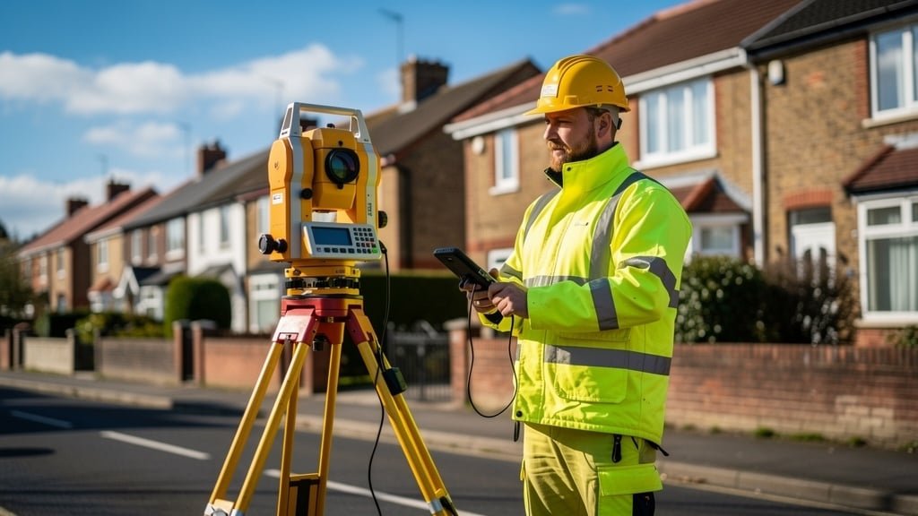
What equipment do topographical surveyors use?

Professional topographical surveyors use highly specialised survey equipment including accurate GPS equipment, total stations, theodolites, laser scanners, drone survey technology, and electronic distance measuring devices. This modern surveying technology allows us to capture precise survey data about land features, contours, and spot levels, which is then processed into detailed CAD drawings and topographic maps.

How long does a topographical survey take to complete?

The survey process typically takes 1-2 days for fieldwork depending on the size of the area of land. Small residential plots may only require a few hours on site. After the survey team completes the field measurements, processing the survey data and creating CAD drawings usually takes 5-10 working days. Rush services are available if you require a topographic survey urgently for planning permission or a development project deadline.

What's the difference between a topographic survey and a measured survey?

A topographic land survey focuses on mapping the natural and manmade features, topography, contour lines, and elevation of outdoor land areas. A measured survey typically documents existing buildings and structures, providing accurate internal and external dimensions. Both types of survey use similar surveying technology and GPS equipment, but serve different purposes. For land development, you'll likely need a topographic survey; for building renovations or extensions, a measured survey is more appropriate.

Do I need a topographic survey for planning permission?

Yes, local authorities typically require a topographical survey as part of planning permission applications for construction projects, extensions, or land development. The survey provides essential information about the existing site conditions, natural topographic features, drainage patterns, and nearby infrastructure. Architects and planners use this survey data to create designs that work with the natural contours of the land and comply with building regulations.

What is included in a topographic survey report?

A comprehensive topographic survey includes: detailed CAD drawings showing all natural and man-made features; contour lines indicating the elevation of the land; spot levels at key points; location of trees, vegetation, and natural topographic features; positions of buildings, fences, walls, and other structures; utilities and drainage features; boundary information; and Ordnance Survey grid references. Surveys provide all the accurate land data your architect or engineer needs for successful project planning.

Are your surveyors accredited and insured?

Yes, all our land surveyors are accredited members of professional bodies including CIOB (Chartered Institute of Building), RICS (Royal Institution of Chartered Surveyors), and RPSA (Residential Property Surveyors Association). We carry full professional indemnity insurance and public liability insurance. This accreditation and insurance protects you and ensures you receive survey services that meet the highest industry standards.

Ready to Start Your Survey Project?

Whether you need a topographic survey for planning permission, a measured survey for property development, or a land survey for site analysis, our expert team is ready to help. Don't let unforeseen issues derail your construction project—get accurate survey data from the start.

Request Your Free Quote Today

Get Your Free Survey Quote

Fill in your details below and one of our professional topographical surveyors will contact you to discuss your survey requirements and provide a competitive quote.